
Garfield ZIP Code Coverage
The verified postal coverage for Garfield is 07026. Research did not locate a second ZIP serving a Garfield street in official USPS or city sources. That is useful as a starting point, but an exact address should still be run through USPS because delivery assignments attach to delivery points and can change. The postal label is a way to route mail. It is not a map of the city line, a parcel boundary, or a roster of people at an address.
| ZIP | Areas Covered | Post Office | Notes |
|---|---|---|---|
| 07026 | Garfield, Bergen County; USPS preferred city is Garfield. | Garfield Post Office, 254 Palisade Ave., Garfield, NJ 07026-9998; Outwater station, 85 Outwater Ln., Ste. 4B, Garfield, NJ 07026-9991. | The official location result identifies the Garfield postal context and nearby Outwater station. Postal geography is not a city-boundary or occupancy map. |
Nearby postal locations in Clifton, Fair Lawn, Lodi, Passaic, Paramus, and the Outwater station are relevant alternatives for service, not additional Garfield ZIPs unless USPS returns one for the particular address.
Search Garfield ZIP Code Three Ways
USPS is the authoritative delivery-point check. Its lookup offers three separate modes, and choosing the right one prevents a common error. Use an address when checking a particular mailing destination, use city and state when surveying the ZIPs returned for a place name, and use cities by ZIP when checking which postal city names USPS associates with a code. Each result answers a postal question only.
| USPS mode | Search fields | Postal result | Limit |
|---|---|---|---|
| By Address | Corporate or residential street address, city, and state. | The ZIP assigned to that delivery address. | Does not identify a person or company at the address. |
| By City and State | City and state. | ZIPs USPS returns for that city. | Not a municipal-boundary search. |
| Cities by ZIP | ZIP. | Cities served by the postal code. | Does not turn the code into a property identifier. |
Use the USPS ZIP Code Lookup for those three postal modes.
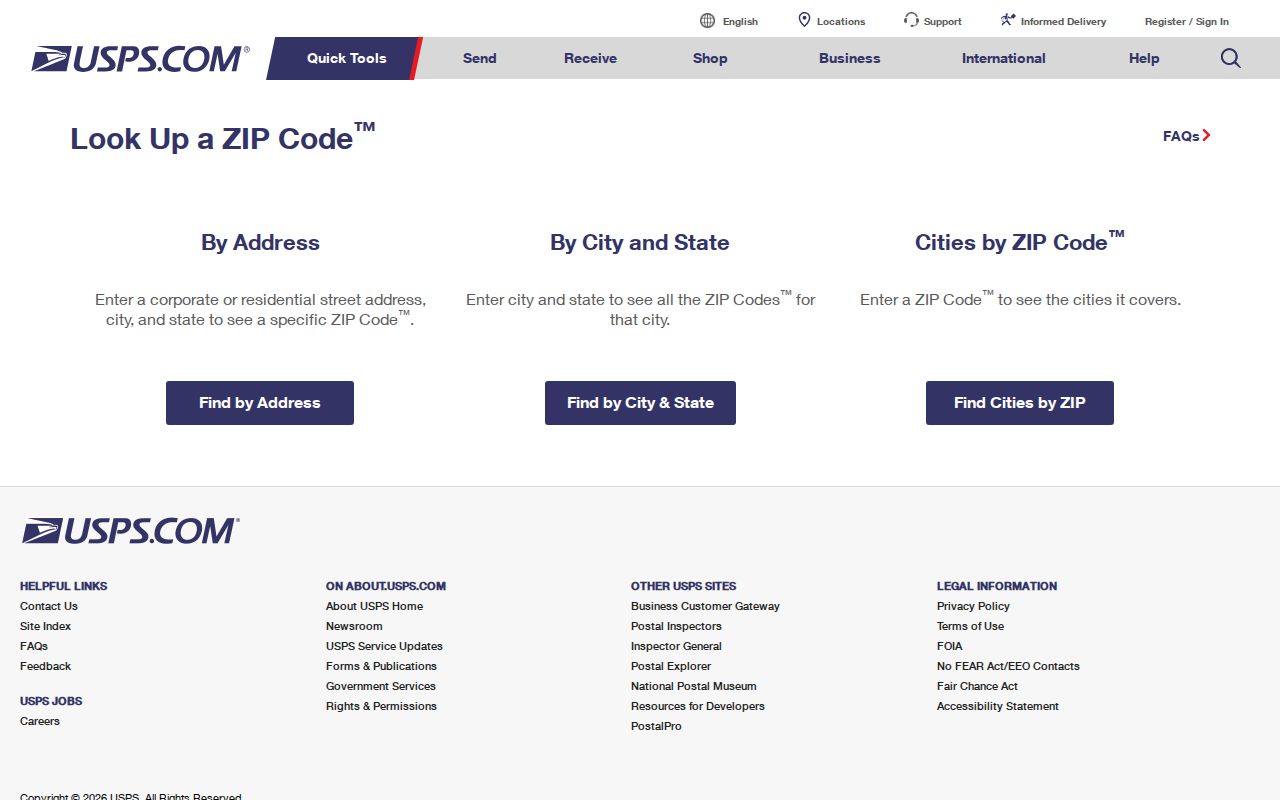
The USPS warning is central: a ZIP result does not confirm that a person or company is at the address. Follow a delivery result with the narrow official record needed for the next question.
Find Records Within a Garfield ZIP Code
A ZIP can narrow the postal starting point, but the local records then switch to municipal and parcel keys. Garfield's official street map is useful for checking the spelling of a street before searching. The assessment portal, GIS viewer, deed system, and election route each operate differently, so a reliable workflow passes the address from one system to the next without claiming that one result proves everything.
- Use the official city street index to normalize the street name, then validate the exact delivery address in USPS.
- Search the NJ Assessment Records Search in Garfield district 0200 by location or by block and lot. Save the situs and parcel identifiers.
- Open the returned parcel area in the Bergen County Parcel Viewer to compare map context and nearby parcel polygons.
- Use the deed, voter, permit, or historical-directory channel only for its narrower purpose. ZIP is not a title identifier and no ZIP-wide voter browse was verified.
Once a postal check narrows the work to one street, use the Garfield street directory for the address-by-address parcel and deed sequence.
Garfield ZIP Code Needs Parcel Keys
New Jersey assessment records are organized by county, district, location, owner, block, lot, and qualifier. The inspected Garfield form did not display a ZIP field. Its practical key is municipality plus block, lot, and qualifier, while a deed relies on town, legal description, book and page, or instrument number. The GIS interface is likewise parcel and map keyed; its text shell did not expose a ZIP filter. A postal code can point a searcher toward the address, but it does not replace the keys used by these systems.
| Record route | Key used | ZIP behavior confirmed | Best next step |
|---|---|---|---|
| Garfield assessment | District 0200, location, owner, block, lot, qualifier. | No visible ZIP filter was observed. | Search by location or parcel fields after USPS validation. |
| Bergen Parcel Viewer | Map and parcel context. | No ZIP filter was exposed in the text shell. | Navigate to the street and compare parcels. |
| Bergen deed index | Town, legal description, parcel or case, lot and block, party, date. | ZIP is not a title identifier. | Use the assessment result to begin the deed chain. |
| Voter status route | Individual status and election channels. | No ZIP-wide browse was verified. | Use the official individual route or lawful county request. |
These differences are not errors. They reflect separate postal, assessment, map, deed, and election purposes.
Garfield ZIP Code Is Not a City Limit
Garfield's city boundaries have remained the same boundaries established in 1898, while USPS ZIP geography is built for mail delivery. The two systems can describe the same address differently without either being wrong. The city sits at the Passaic and Saddle River junction, near Clifton, Passaic, Lodi, Wallington, Elmwood Park, and Fair Lawn. Nearby place names may appear in postal context, yet they should not be treated as extra Garfield coverage unless the USPS result for that exact delivery point says so.
- ZIP
- A postal routing code for a delivery address, not a municipal border or a parcel key.
- ZIP+4
- The additional four digits that refine delivery routing within a ZIP. It does not identify a household.
- PO Box ZIP
- A code used for post-office boxes. Mail may use it even when the physical property lies elsewhere.
- Unique ZIP
- A postal code assigned to one organization or destination. No unique ZIP for Garfield was verified in the researched sources.
- Carrier route
- A postal delivery grouping. It is not a city-limit, title, or resident record.
For a legal property boundary, consult a deed, plat, and professional survey rather than a USPS result or GIS polygon.
USPS ZIP Code Does Not Prove Occupancy
A useful caution. A valid postal result proves only that USPS recognizes the delivery address. It does not establish that a named person or company receives mail there. A resident may use a PO Box or alternate station, an estate or business may use another mailing address, and a property owner may receive tax notices outside Garfield. The most reliable cross-check is to use the appropriate record for the question: USPS for delivery, assessment for a parcel's recorded owner and situs, deeds for transfer history, and the election custodian for lawful registration information.
That discipline avoids turning a mail-routing result into an unsupported claim about a resident, owner, or business.
Garfield 07026 Postal Stations
The USPS location result lists the Garfield Post Office at 254 Palisade Avenue and the Outwater station at 85 Outwater Lane, Suite 4B. The listed retail schedule is Monday through Wednesday and Friday from 9 a.m. to 5 p.m., Thursday from 9 a.m. to 5 p.m., Saturday from 10 a.m. to 4 p.m., and Sunday closed. The listed numbers are 973-478-0897 and 1-800-275-8777. Postal hours can change, so recheck before making a visit.
Open the Garfield Post Office location result for the verified station and nearby Outwater context.
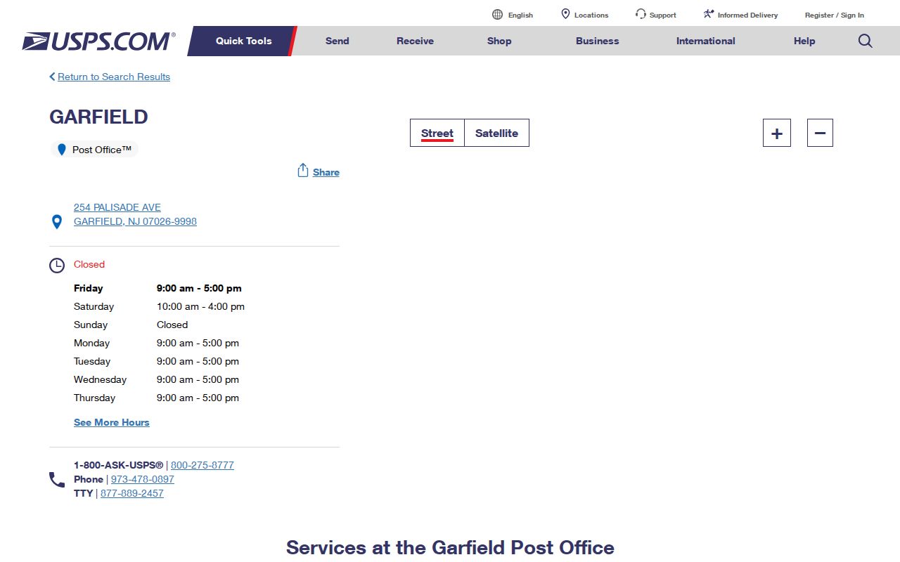
The two station listings support the 07026 postal context, while the assessment and county records remain the routes for parcel questions.
Garfield ZIP Codes and Census Areas
Census geography is a separate map language. The Census address tool can associate an address or ZIP with a census geography such as a tract, block, place, or ZCTA. Those boundaries are not identical to USPS delivery ZIPs and should not be used to identify a person. It is useful when the question is geographic context rather than delivery routing or parcel ownership.
Garfield ZIP Code River Context
Garfield covers 2.08 square miles at the Passaic and Saddle River junction. Its dense map-indexed streets and river crossings make exact address checking more useful than a broad place-name assumption. Robertsford is a historic locality name tied to the Jewell Street area, and Robertsford Bridge became Veterans Bridge toward Outwater Lane and Ackerman Avenue in Clifton. Those historic names can help locate older maps, newspapers, deeds, or directories, but they do not create another postal designation.
Older records may also use the borough or city form of Garfield because the place was part of Saddle River Township, then a borough in 1898, and the City of Garfield in 1917. Search variants are historical context, not proof of a present delivery ZIP.
Limits of a Garfield ZIP Code Directory
A Garfield ZIP code directory is strongest when it answers a postal question precisely and hands the next question to the correct records custodian. It can confirm verified 07026 coverage, show which USPS lookup mode fits the question, and distinguish postal geography from municipal, assessment, deed, and Census systems. It cannot identify an occupant, prove a city line, substitute for a survey, or turn a ZIP into a legal description.
Use the exact address for USPS verification, Garfield district 0200 and block or lot for assessment work, and town or legal-description fields for Bergen land records. Confirm any time-sensitive postal or office detail directly with the responsible office.
Note: No official Garfield ZIP split, realignment date, PO-box-only code, unique ZIP, or second street-serving ZIP was located in the researched sources.